Easter Island, a Chilean territory, is a remote volcanic island in Polynesia. Its native name is Rapa Nui. It’s famed for archaeological sites, including nearly 900 monumental statues called moai, created by inhabitants during the 13th–16th centuries. 

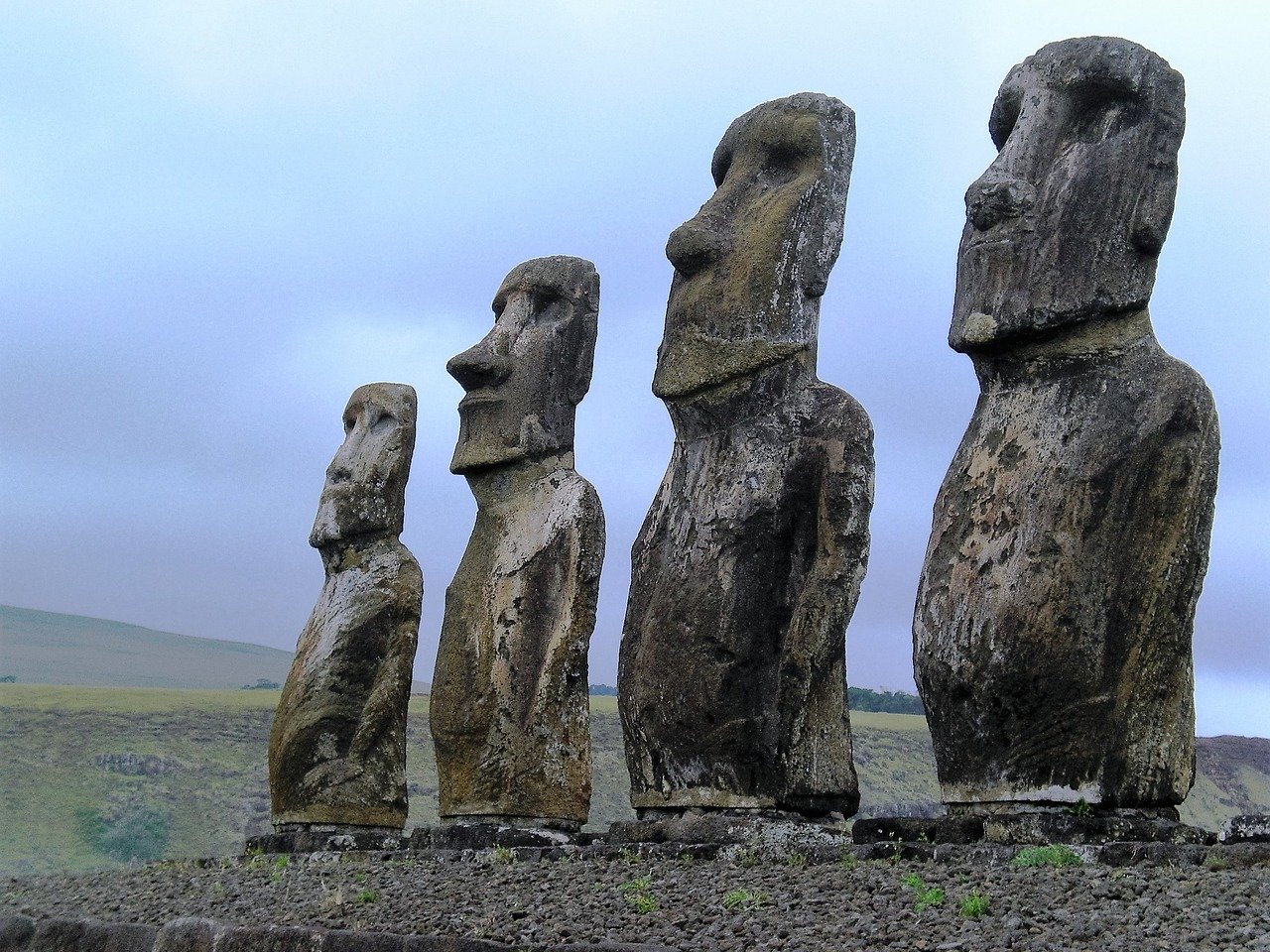
The moai are carved human figures with oversize heads, often resting on massive stone pedestals called ahus. Ahu Tongariki has the largest group of upright moai.

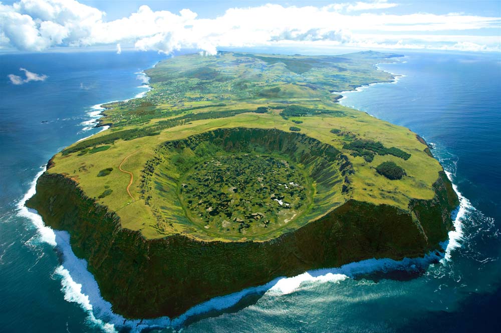
The name Easter Island was given by Jacob Roggeveen, the first recorded European visitor to the island on 5 April 1722, which so happened to be Easter Sunday.  

There are nearly 900 Moai on Easter Island, in various stages of construction. The average size of a Moai statue is 13 feet tall and 14 tons.

Built to honour a chieftain or important people the natives believed the spirit of the person would forever watch over the tribe and bring good fortune. This is why the statues are called Moai: the word comes from Rapa Nui (the Polynesian language of Easter Island) and means “so that he can exist”. 

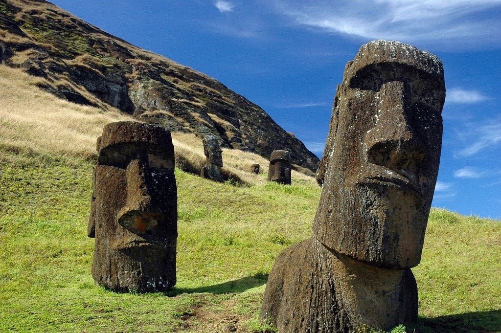
None of the Moai statues were standing when scientists first arrived, those upright today have been re-erected. 

Although commonly known as the ‘Easter Island heads’ this is a misconception as it was discovered in 2012 that all of the heads have full bodies which have become submerged.

See More Places

If you’ve ever visited one the Mayan pyramids on a trip to Cancun or the Mayan Riviera, the structure’s complex construction and simple beauty surely caught your imagination.

But when you learn the history and significance of the pyramids, as well as the facts surrounding their construction some 9,000 years ago, casual interest turns to wonder.

And not all Mayan pyramids are constructed alike. The ancient Mayans built two types of pyramids: some to use for sacrificial rituals and some intended to remain untouched.

In yesteryear, almost all of these pyramids were open to the public, and anyone who wished to attempt a climb was free to do so. Today, restrictions often forbid this. While that may disappoint visitors, it’s easy to see how climbing can be destructive to the ruins and dangerous to tourists. And there is still a lot of terrain to cover to experience the ruins of a Mayan city.

See More Places

Monument Valley, a red-sand desert region on the Arizona-Utah border, is known for the towering sandstone buttes of Monument Valley Navajo Tribal Park.

Known for its majestic, free-standing sandstone buttes, this sprawling, 92,000-acre valley attracts more than 250,000 sightseers per year.

Visitors come to this isolated area on the Arizona-Utah border to hike, drive, photograph or simply experience its natural and ever-changing beauty.

But contrary to popular belief, Monument Valley is not on public land. Unlike many nearby national parks in Arizona and Utah, Monument Valley is a tribal park owned and operated by the Navajo Nation.

John Ford “discovered” the area in the 1930s and began filming Western movies there, propelling the landscape into international fame.

Monument Valley is still a favorite location for filmmakers. Blockbusters like Back to the FutureMission ImpossibleThe Lone Ranger and Transformers: Age of Extinction were shot there. The valley even appears in the 2014 film The Lego Movie.

The Navajo name for the park is Tsé Biiʼ Ndzisgaii, or Valley of the Rocks. Ten families make their homes inside the park, where they live without running water or electricity and rely on farming and grazing for income.

A 17-mile loop road takes visitors through the park. Locals ask that visitors respect their privacy and stay on marked trails and roads.

“Because people live in the valley, they do want their peace and quiet,” Parrish said. “We ask that visitors exit before the sun goes down.”

See More Places

Niagara Falls is a group of three waterfalls at the southern end of Niagara Gorge, spanning the border between the US state of New York and the Canadian province of Ontario. 

Niagara Falls State Park is the oldest state park in America, established in 1885 at the Niagara Reservation. Over 8 million visitors explore Niagara Falls State Park annually. 

Niagara Falls is comprised of three waterfalls, from largest to smallest, the Horseshoe Falls (also known as the Canadian Falls), American Falls and Bridal Veil Falls. 

Niagara Falls’ vertical height is over 176 feet in some sections.

The birth of Niagara Falls can be traced back more than 12,000 years to the end of the last glacial period.

Despite myths to the contrary, Niagara Falls does not freeze in the winter. However, the flow of water was reduced to a mere trickle for a few hours on March 29, 1848 because of an ice jam upstream in the Niagara River.

See More Places

Horseshoe Bend is a horseshoe-shaped incised meander of the Colorado River located near the town of Page, Arizona, United States. 

Horseshoe bend resides 1,000 feet above the rivers surface which is equivalent to a 99-storey building.

The formation was created over the course of a billion years and was caused by the continual flow of water through the canyon walls.

The hike and travel to this location is well worth the effort. Most tourists do not even know about this beautiful location and instead gather around more well-known locations throughout the Grand Canyon. On most days you can drive all the way to the parking lot and easily find a spot to park your vehicle. A half mile hike down the trail leads you directly to the bend and as the trail gives way to nothingness below you will understand why Horseshoe Bend on the Colorado River is a must see place before  you die.

See More Places

Moraine Lake is a glacially fed lake in Banff National Park, 14 kilometres outside the Village of Lake Louise, Alberta, Canada. It is situated in the Valley of the Ten Peaks, at an elevation of approximately 1,884 metres. The lake has a surface area of 50 hectares.

The area around the lake has several walking/hiking trails which are, from time to time, restricted. The trail most commonly taken by tourists is The Rockpile Trail, which is along the actual moraine.

The trail is approximately 300 metres (980 ft) long, with an elevation change of 24 metres (79 ft). The view of the lake from the top of the rockpile is one of the most photographed locations in all of Canada.

That view of the mountains behind the lake in Valley of the Ten Peaks is known as the “Twenty Dollar View”, as Moraine Lake was featured on the reverse side of the 1969 and 1979 issues of the Canadian twenty dollar bill.

See More Places